I am a geomorphologist interested in earth surface processes. I use numerical modeling, remote sensing, and field work in my research. Right now, I am focusing on erosion upon reclaimed mountaintop removal coal mines in Central Appalachia.
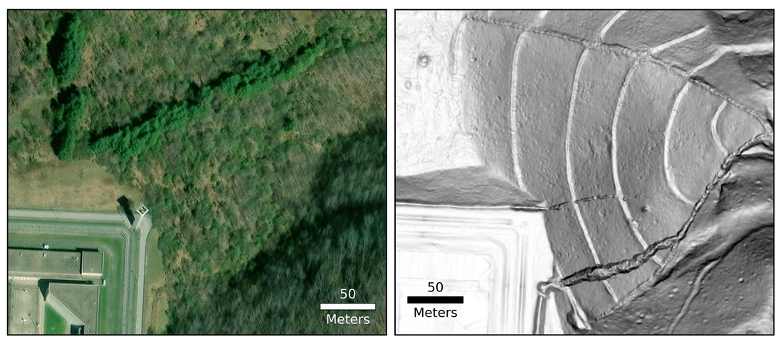
Here we see a large gully on a valley fill caused by runoff from the Big Sandy Federal Penitentiary in Martin County, Kentucky. Left is the a true color satellite image and right is a lidar-derived slopeshade.
I found many actively eroding landslides and gullies in the eastern Kentucky coalfields. Depending on the location, this region has up to three epochs of high-resolution lidar data.

Lidar-derived slopeshade with vertical difference (between 2012 and 2019) overlay showing a large failure in a valley fill in Floyd County, Kentucky. Red represents erosion and blue represents deposition. Houses are present below the valley fill.
I am interested in using deep-learning (DL) methods to identify landforms in high-resolution lidar imagery. Check out my postdoc mentor's recent paper showcasing his new DL framework designed specifically for geomorphic feature extraction.
During my PhD work with Ken Ferrier at the University of Wisconsin-Madison's Department of Geoscience, I focused on mainly numerical modeling. I incorporated cosmogenic nuclides into a landscape evolution model (paper; code).
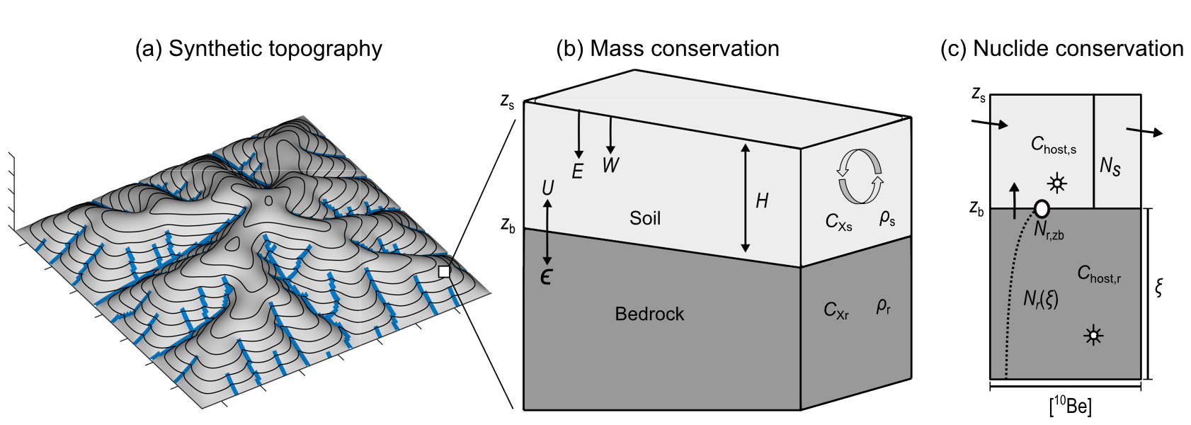
Schematic of model behavior. Each hillslope cell maintains both mass and nuclide conservation. Refer to Reed et al. (2023; Journal of Geophysical Research: Earth Surface) for symbol descriptions.
After incorporating temperature-sensitive soil production, hillslope sediment transport, and chemical erosion, I applied the model to a site in Little Lake, Oregon, with a high-resolution archive of landscape change with many paleo-denudation rates, a very rate dataset. I was interested in whether these temperature-sensitive processes better explained the field-derived data (paper; code).

Modeled responses of Little Lake to an onset of frosty conditions. [Top] Modeled actual denudation rates (Dact) and inferred denudation rates (Dinf) through time compared to Little Lake paleo-denudation rates inferred from concentrations of 10Be in quartz found a paleo-lacustrine sedimentary archive (core). [Middle] Modeled chemical depletion fraction (fraction of inferred denudation rate attributable to chemical erosion) compared to core measurements. [Bottom] Modeled mean soil thickness (H) and temperature (T; for reference).
I also used energy dispersive spectroscopy data to differentiate minerals in thin sections with a special interest in the mineral biotite, which is thought to be important in the weathering of fresh bedrock. I developed a free and open-source method in the QGIS environment to perform a machine-learning based automated mineralogy workflow (paper; code).

Schematic workflow of machine-learning based (here, random forest) automated mineralogy method.